Global S&T Development Trend Analysis Platform of Resources and Environment
| Global TanDEM-X forest map is available | |
| admin | |
| 2019-05-06 | |
| 发布年 | 2019 |
| 语种 | 英语 |
| 国家 | 德国 |
| 领域 | 地球科学 |
| 正文(英文) |
Global TanDEM-X forest map
The global TanDEM-X Forest/Non-Forest Map was derived from interferometric radar data and is freely available for scientific applications. Credit: DLR.
TanDEM-X forest map – Alps
Section of the TanDEM-X forest map over the Alps. Credit: DLR.
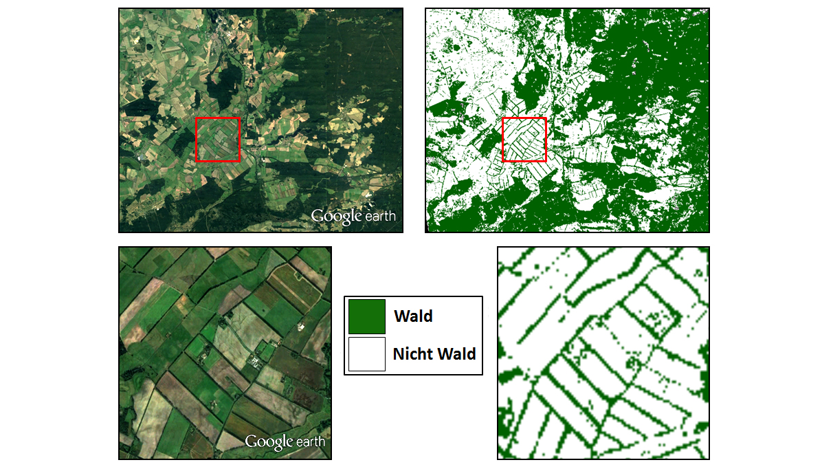
TanDEM-X forest map – southern Germany
Comparison of a Google Earth image with the TanDEM-X forest map for a region in southern Germany. Individual rows of trees at the edges of fields can be clearly distinguished in the image, demonstrating the degree of detail offered by the forest map. Credit: Google Earth/DLR.
Dramatic deforestation in Brazil
The TanDEM-X Forest/Non-Forest Map for an approximately 250-kilometre by 250-kilometre area in the Brazilian state of Rondônia shows the dramatic development of deforestation in the rainforest. Credit: DLR.
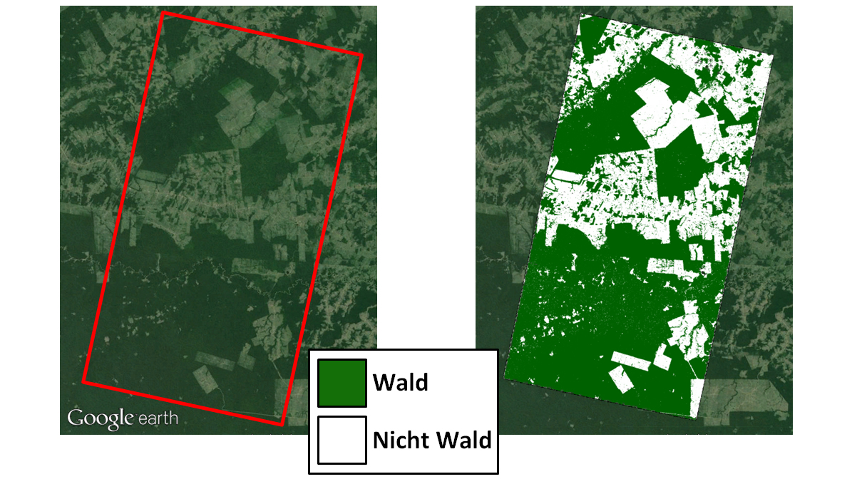
Comparison – deforestation in the Amazon
Comparison between a Google Earth image and the TanDEM-X forest map for an area in the Amazon rainforest affected by deforestation. For the first time, the TanDEM-X data provide a precise insight and overview of deforestation in the most remote regions, so that illegal activities in particular can be detected. Credit: GoogleEarth/DLR.
Forests are Earth's lungs; they help to reduce greenhouse gas concentrations in the atmosphere and thus counteract global warming, while also providing protection and resources for humans, animals and plants – and they are being lost at an alarming rate. As the view from space reveals, forests cover about one third of Earth’s landmass today. More than half of the world’s forests, which have fallen victim to deforestation since the middle of the 20th century in particular, have already been lost. The German Aerospace Center (Deutsches Zentrum für Luft- und Raumfahrt; DLR) has created a special dataset to monitor, assess, and protect the current state and development of this green organ with precision – the global TanDEM-X Forest/Non-Forest Map. Interferometric data acquired by the German TanDEM-X radar satellite mission for the creation of a global elevation model were used for this purpose; algorithms from the field of Artificial Intelligence were developed for global data processing. These have been optimised for different types of forests based on tree height, density, and structure. This has resulted in a global map that shows the extent of forested areas at a resolution of 50 metres. DLR’s global TanDEM-X Forest/Non-Forest Map is now available free of charge to scientific users. Radar satellites can acquire image data regardless of the weather or time of day – a particular advantage when it comes to mapping tropical forests, which are usually covered by clouds. The TanDEM-X Forest/Non-Forest Map closes the gaps that previously existed in the data and, for the first time, provides a uniform overview of the rainforests in South America, Southeast Asia, and Africa. The findings are important for authorities and scientists alike, as these areas must be protected from illegal logging and preserved as important stores of carbon. The new map can also help scientists to more precisely determine the forest biomass – a key factor when studying the global carbon cycle. The TanDEM-X Forest/Non-Forest Map thus provides an important dataset for research into global change and makes a variety of applications in agriculture, forestry, regional development, and land-use planning possible. In addition, it also allows more precise predictions to be made and appropriate measures to be taken to address the societal challenges arising from global change. Big Data and Artificial Intelligence The DLR Microwaves and Radar Institute has processed more than 400,000 datasets for the project. The datasets were acquired between 2011 and 2015 as part of the TanDEM-X mission. The radar experts have developed special algorithms that first evaluate each image individually and then combines them to form a global map with the goal of extracting and classifying forest-related information from the vast quantities of data. These algorithms are based on machine learning in the field of Artificial Intelligence. More information is available in an article published in the journal 'Remote Sensing of Environment' (Volume 205, February 2018). In the future, it will be possible to evaluate new satellite data and compare it with the global TanDEM-X map, for instance using time series analyses. The developers used additional remote sensing data to validate the calculated results and differentiate forest areas from non-forested regions with a greater degree of accuracy. In particular, this includes the ‘global urban footprint’, a global map of settlements created at the DLR Earth Observation Center (EOC), as well as the mapping of water bodies by ESA’s Climate Change Initiative. The distribution of the global TanDEM-X Forest/Non-Forest Map is managed by the German Satellite Data Archive at the EOC and made available to users. The German Space Operations Center (GSOC) is responsible for the operation of the TanDEM-X radar satellite mission. Tandem-L – forest monitoring in the future Assessing and monitoring forest resources is a key task for current and future radar satellite missions. In particular, Tandem-L – a proposal for a highly innovative satellite mission – could in the future generate forest maps on a weekly basis and derive forest height, structure, and biomass accordingly. With its innovative imaging technology and the resulting enormous recording capacity, Tandem-L is also designed to observe other dynamic environmental processes on the Earth’s surface. The mission will set new standards in Earth observation and thus significantly contribute towards addressing global societal challenges. |
| URL | 查看原文 |
| 来源平台 | German Aerosapce Center |
| 文献类型 | 新闻 |
| 条目标识符 | http://119.78.100.173/C666/handle/2XK7JSWQ/128963 |
| 专题 | 地球科学 |
| 推荐引用方式 GB/T 7714 | admin. Global TanDEM-X forest map is available. 2019. |
| 条目包含的文件 | 条目无相关文件。 | |||||
| 个性服务 |
| 推荐该条目 |
| 保存到收藏夹 |
| 查看访问统计 |
| 导出为Endnote文件 |
| 谷歌学术 |
| 谷歌学术中相似的文章 |
| [admin]的文章 |
| 百度学术 |
| 百度学术中相似的文章 |
| [admin]的文章 |
| 必应学术 |
| 必应学术中相似的文章 |
| [admin]的文章 |
| 相关权益政策 |
| 暂无数据 |
| 收藏/分享 |
除非特别说明,本系统中所有内容都受版权保护,并保留所有权利。


修改评论