Global S&T Development Trend Analysis Platform of Resources and Environment
| Emerging cracks in the Pine Island Glacier | |
| admin | |
| 2019-10-18 | |
| 发布年 | 2019 |
| 语种 | 英语 |
| 国家 | 欧洲 |
| 领域 | 地球科学 |
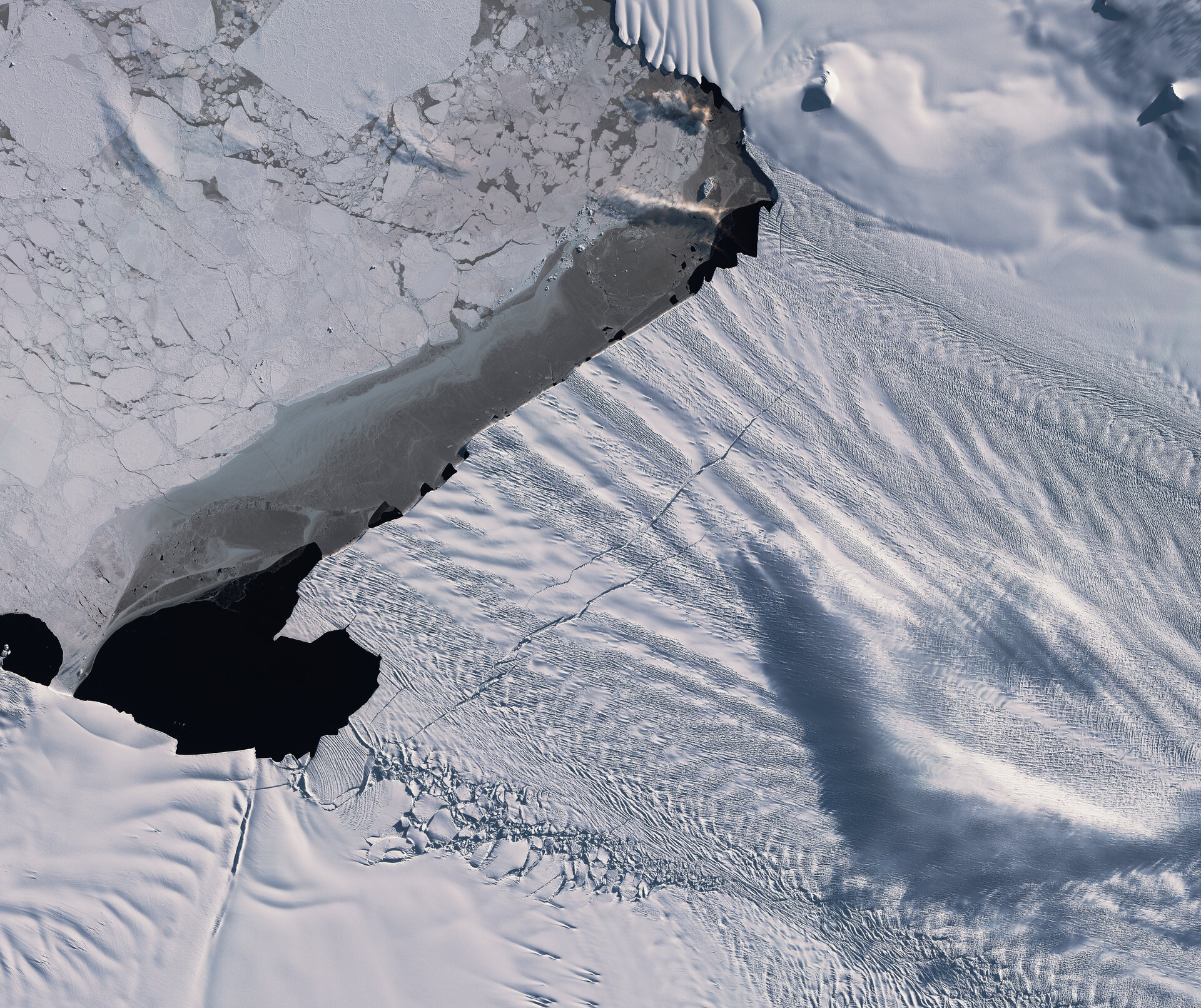
| 正文(英文) | The Copernicus Sentinel-1 and Sentinel-2 satellites have revealed new cracks, or rifts, in the Pine Island Glacier – one of the primary ice arteries in the West Antarctic Ice Sheet. The two large rifts were first spotted in early 2019 and have each rapidly grown to approximately 20 km in length. Mark Drinkwater, Head of the Earth and Mission Sciences Division at ESA, says, “These new rifts appeared very soon after last year’s major calving of iceberg B46. Sentinel-1 winter monitoring of their progressive extension signals that a new iceberg of similar proportions will soon be calved.” 
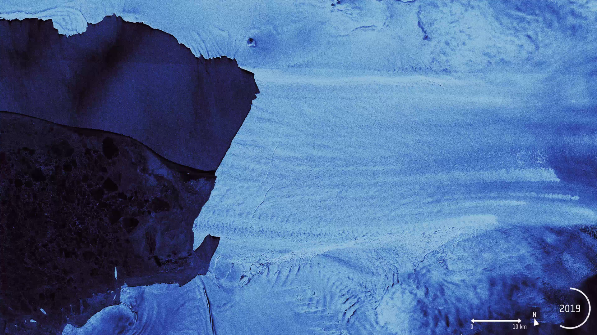
Evolution of the cracks in the Pine Island Glacier
Access the video Pine Island Glacier, along with its neighbour Thwaites glacier, connect the centre of the West Antarctic Ice Sheet with the ocean – together discharging significant quantities of ice into the ocean. These two glaciers have been dramatically losing ice over the last 25 years. Owing to their extremely remote location, satellites play a critical role in measuring and monitoring Antarctic glaciology – revealing the timing and pace of glacial retreat in Antarctica. Since the early 1990s, the Pine Island Glacier’s ice velocity has increased dramatically to values which exceed 10 m a day. Its floating ice front, which has an average thickness of approximately 500 metres, has experienced a series of calving events over the past 30 years, some of which have abruptly changed the shape and position of the ice front. These changes have been mapped by ESA satellites since the 1990s, with calving events occurring in 1992, 1995, 2001, 2007, 2011, 2013, 2015, 2017 and 2018. The last of which, named B46 by the US National Ice Center, was approximately 226 sq. km in size. The ERS-1, ERS-2, Envisat and Copernicus Sentinel-1 satellites have previously provided images with to monitor changes in these glaciers. With routine, year-round Copernicus Sentinel-1 images, it is possible to track changes in the speed of the ice flow, to monitor the migration of the grounding line, and the development of fractures and rifts which ultimately lead to iceberg calving events. Importantly, Copernicus Sentinel-1’s advanced synthetic aperture radar (SAR) can image Earth’s surface through rain and cloud, day or night. This is particularly useful for monitoring Antarctic areas throughout the prolonged periods of winter darkness. Recently, the frequency of Pine Island Glacier calving events has increased. Today, the glacier is observed to be losing mass by a combination of calving events together with strong basal melting, where warm ocean currents erode the underside of the floating ice shelf. As the ice shelf both thins and calves enormous icebergs, the glacier discharge is unable to replenish the ice lost and the ice shelf front recedes from its previous position. “Long-term measurements of West Antarctic Ice Sheet glaciers such as Pine Island are critical to understanding changes to the rate of loss of ice mass into the ocean, and thus Copernicus Sentinel-1 has become fundamental to gauging Antarctica’s contribution to rising sea levels,” says Mark Drinkwater. |
| URL | 查看原文 |
| 来源平台 | European Space Agency |
| 文献类型 | 新闻 |
| 条目标识符 | http://119.78.100.173/C666/handle/2XK7JSWQ/216093 |
| 专题 | 地球科学 |
| 推荐引用方式 GB/T 7714 | admin. Emerging cracks in the Pine Island Glacier. 2019. |
| 条目包含的文件 | 条目无相关文件。 | |||||
| 个性服务 |
| 推荐该条目 |
| 保存到收藏夹 |
| 查看访问统计 |
| 导出为Endnote文件 |
| 谷歌学术 |
| 谷歌学术中相似的文章 |
| [admin]的文章 |
| 百度学术 |
| 百度学术中相似的文章 |
| [admin]的文章 |
| 必应学术 |
| 必应学术中相似的文章 |
| [admin]的文章 |
| 相关权益政策 |
| 暂无数据 |
| 收藏/分享 |
除非特别说明,本系统中所有内容都受版权保护,并保留所有权利。


修改评论