Global S&T Development Trend Analysis Platform of Resources and Environment
| New map of Greenland reveals fast-changing environment | |
| admin | |
| 2019-06-13 | |
| 发布年 | 2019 |
| 语种 | 英语 |
| 国家 | 英国 |
| 领域 | 资源环境 |
| 正文(英文) | A new map of Greenland and the European Arctic highlights the importance of monitoring environmental change in this fast-changing region. Cartographers at British Antarctic Survey (BAS) have produced the most detailed and up-to-date printed map of Greenland. This map is the first of its kind to cover the entire region on one sheet. The map stretches from the Canadian Arctic in the west, to the Russian Arctic in the east. Mapping this region is extremely challenging. Maintaining accurate map records allows researchers to track and investigate the fast-changing Arctic environment. Glacier and ice-sheet retreat is causing coastlines in the region to evolve, creating new bays and fjords which feature. One of the most significant areas of improvement is over Greenland. Historically, due to its remote location and low population density, data collection and the creation of maps in Greenland has been more difficult than in other areas. To overcome this, BAS cartographers extracted the coastline from an existing dataset and updated it using over forty satellite images at 30-m resolution. The updated coastline and interior includes new features such as islands in the Qimusseriarsuaq (Melville Bay) region, revealed by the retreat of the Greenland ice sheet. It also exposes the extension of the Ilulissat Icefjord at the front of Jakobshavn Isbræ, a glacier well-known for its dramatic recent retreat. GIS and Mapping Specialist at BAS, Laura Gerrish says:
The reverse of the map provides a wealth of information on the region, its people and the environmental changes facing the Arctic. This information panel was produced by the NERC Arctic Office with inputs from organisations including the Association of Arctic Expedition Cruise Operators (AECO), WWF and the Met Office. Head of the NERC Arctic Office, Henry Burgess, says:
The Greenland and the European Arctic map is available for purchase as either a flat wall map or a folded map at several outlets including Stanfords map store in London (www.stanfords.co.uk) and the Scott Polar Research Institute (https://www.spri.cam.ac.uk/shop). 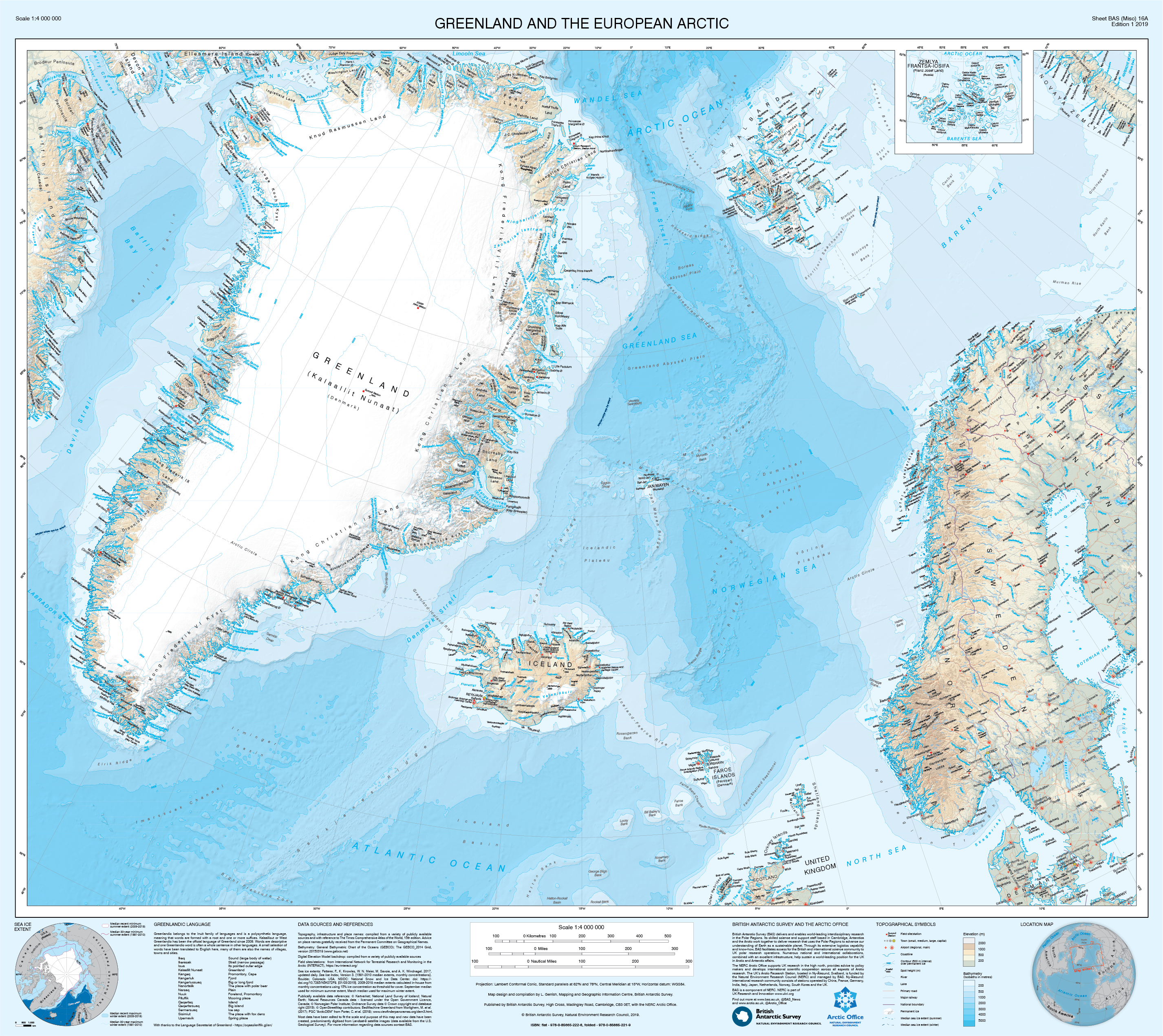 |
| URL | 查看原文 |
| 来源平台 | British Antarctic Survey |
| 文献类型 | 新闻 |
| 条目标识符 | http://119.78.100.173/C666/handle/2XK7JSWQ/233708 |
| 专题 | 资源环境科学 |
| 推荐引用方式 GB/T 7714 | admin. New map of Greenland reveals fast-changing environment. 2019. |
| 条目包含的文件 | 条目无相关文件。 | |||||
| 个性服务 |
| 推荐该条目 |
| 保存到收藏夹 |
| 查看访问统计 |
| 导出为Endnote文件 |
| 谷歌学术 |
| 谷歌学术中相似的文章 |
| [admin]的文章 |
| 百度学术 |
| 百度学术中相似的文章 |
| [admin]的文章 |
| 必应学术 |
| 必应学术中相似的文章 |
| [admin]的文章 |
| 相关权益政策 |
| 暂无数据 |
| 收藏/分享 |
除非特别说明,本系统中所有内容都受版权保护,并保留所有权利。


修改评论