Global S&T Development Trend Analysis Platform of Resources and Environment
| Earth from Space: Kuala Lumpur, Malaysia | |
| admin | |
| 2021-11-19 | |
| 发布年 | 2021 |
| 语种 | 英语 |
| 国家 | 欧洲 |
| 领域 | 地球科学 |
| 正文(英文) | Kuala Lumpur, the capital city of Malaysia, is featured in this image captured by the Copernicus Sentinel-2 mission. Click on the image below to explore it in its full 10 m resolution. 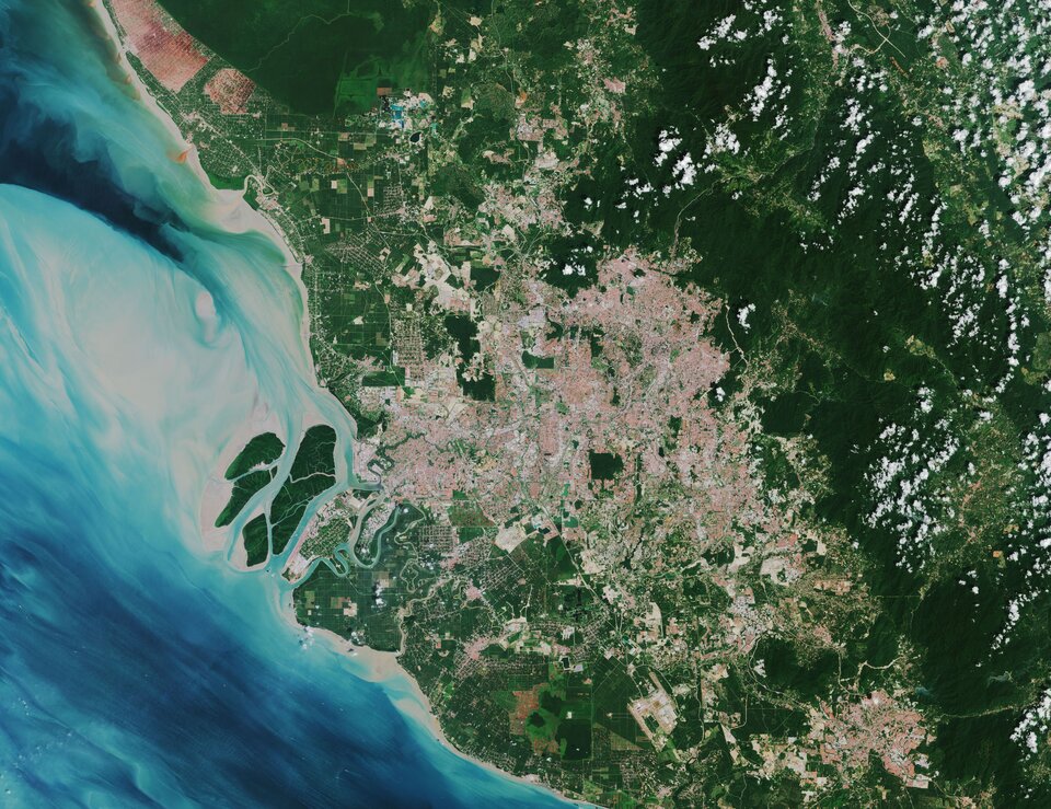
Located in west-central Malaysia, Kuala Lumpur is the country’s largest urban area and its cultural, commercial and transportation centre. The city lies in the hilly countryside of the Klang Valley and lies astride the confluence of the Kelang and Gombak rivers. Its name in Malay means ‘muddy estuary.’ The city’s commercial quarter, known as the Golden Triangle, is the site of the Petronas Twin Towers, the tallest twin towers in the world. Kuala Lumpur International Airport, one of the busiest airports in Asia, can be seen in the bottom of the image. The Klang Valley is bordered by the Titiwangsa Mountains to the east, some minor ranges in the north and the Strait of Malacca in the west. Visible in the far left of the image, the Strait of Malacca is a narrow stretch of water between the Malay Peninsula and the Indonesian island of Sumatra. A main shipping channel between the Indian and Pacific oceans, it is one of the most important shipping lanes in the world. Port Klang, is the main gateway by sea into Malaysia and lies around 40 km southwest of Kuala Lumpur. The Greater Kuala Lumpur area is around 2700 sq km and is an urban agglomeration of over seven million people – making it one of the fastest growing metropolitan regions in Southeast Asia. Like many other growing cities and areas in the world, the region is facing the daunting challenge of urban sprawl. This puts pressure on urban land in the city, but also on agricultural land in the periphery, as well as on other natural resources. Urban areas are already home to 55% of the world’s population and that figure is expected to grow to 68% by 2050. In order to gain a better understanding of current trends in global urbanisation, ESA and the German Aerospace Center (DLR), in collaboration with the Google Earth Engine team, have jointly developed the World Settlement Footprint – the world’s most comprehensive dataset on human settlement. 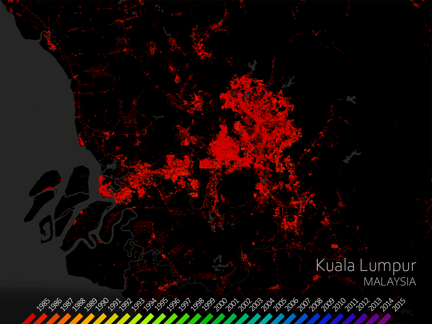
The World Settlement Footprint Evolution has been generated by processing seven million images from the US Landsat satellite collected between 1985 and 2015. The animation on the right illustrates the growth of Kuala Lumpur on a year-by-year basis, from 1985 to 2015. This unprecedented collection of information on human settlement will not only advance our understanding of urbanisation on a global scale but will also become an asset for national statistical offices, local authorities, civil society and international organisations. For more information on the World Settlement Footprint, click here. This image is also featured on the Earth from Space video programme. 
Earth from Space: Kuala Lumpur, Malaysia
Access the video |
| URL | 查看原文 |
| 来源平台 | European Space Agency |
| 文献类型 | 新闻 |
| 条目标识符 | http://119.78.100.173/C666/handle/2XK7JSWQ/341618 |
| 专题 | 地球科学 |
| 推荐引用方式 GB/T 7714 | admin. Earth from Space: Kuala Lumpur, Malaysia. 2021. |
| 条目包含的文件 | 条目无相关文件。 | |||||
| 个性服务 |
| 推荐该条目 |
| 保存到收藏夹 |
| 查看访问统计 |
| 导出为Endnote文件 |
| 谷歌学术 |
| 谷歌学术中相似的文章 |
| [admin]的文章 |
| 百度学术 |
| 百度学术中相似的文章 |
| [admin]的文章 |
| 必应学术 |
| 必应学术中相似的文章 |
| [admin]的文章 |
| 相关权益政策 |
| 暂无数据 |
| 收藏/分享 |
除非特别说明,本系统中所有内容都受版权保护,并保留所有权利。


修改评论